Point Stephens, Port Stephens and Black Head
Grade 5: A most picturesque area where Cook’s precise descriptions of the landscape are readily identified, and which in many respects remains much as those aboard Endeavour would have experienced it. A visit will not disappoint!
Situation: Port Stephens is about 230 km north of Sydney.
Coordinates (decimal):
Point Stephens: 32.75 S 152.20 E
Port Stephens: 32.70 S 152.13 E
Aboriginal Name: Port Stephens – Yacaaba
Endeavour Journal, 11 May 1770:
At 4 PM past at the distance of 1 Mile a low rocky point which I named Point Stephens (Latde 32.45) on the north side of this is an inlet which I called Port Stephens (Lat. 32.40, Logde 207.51) that appear’d to me from the mast head to be shelter’d from all winds. At the entrance lay 3 small Islands two of which are of a tolerable height and on the Main near the shore are some high round hills that make at a distance like Islands, in passing this bay at a distance of 2 or 3 Miles from the shore our soundings were from 33 to 27 fathoms from which I conjector’d that there must be sufficient depth of water for shipping in the Bay. We saw several smooks a little way in the Country rise up from the flat land, by this I did suppose that there were lagoons which afforded subsistence for the natives such as shell fish &ca for we as yet know nothing else they live upon.
Cook’s ‘3 small islands’ are, in order of size from largest to smallest, Cabbage Tree Island, Boondelbah Island and Little Island. The ‘high round hills’ are Tomaree Point, Yacaaba Head, Stephens Peak, and the hill above Point Stephens.
Time being of the essence, as at Jervis Bay and Port Jackson Cook did not attempt to enter Port Stephens. Cook named Port Stephens for Phillip Stephens, Joint Secretary at the Admiralty at the time of Cook’s departure. Stephens’ name appears on Cook’s sailing instructions for the voyage. The other Joint Secretary, George Jackson, was earlier commemorated at Port Jackson. Both were also commemorated by Cook on the coast of New Zealand. It is interesting that Jackson and Stephens, closely associated at the Admiralty, were to be closely associated on this coast by the naming of consecutively sighted harbours. Prior to the Endeavour voyage Cook had spent several northern summers surveying the coast of Newfoundland. During the winters he returned to London to draw up his charts and spent time at the Admiralty. Cook was well known to Stephens who, aware of his extraordinary abilities, recommended him to lead the Endeavour voyage.
There are two important viewpoints for the Cook Landmarks at Port Stephens and both require some walking.
Point Stephens:
The first is from Point Stephens itself. Park behind the beach at Fingal Bay, cross the dunes to the beach, turn left and follow the bay until you reach the spit of sand between the mainland and the part time island on which Point Stephens resides. Crossing the spit to the island is dangerous and should only be attempted at low tide. The condition of the spit varies as storms can erode it. Check locally before attempting a crossing. Once on the island follow the sandy track ascending ahead. Follow this and a bit less than half an hour after crossing the spit you will round a bend and see Point Stephens lighthouse ahead. From the point beyond the lighthouse look north and you will see the vista that greeted Cook when he arrived off this point at 4 p.m. on 11 May 1770. He observed (and named) from one mile off shore of the ’low rocky point’ on which you are standing, ‘3 small Islands two of which are of a tolerable height and on the Main near the shore are some high round hills that make at a distance like Islands’. The three islands Cook mentions are in the foreground – the westernmost and largest is Cabbage Tree Island, the next largest and nearest is Boondelbah Island, and the third and smallest is Little Island.
Black Head:
Beyond the three islands is what looks like a distant headland. Cook named this as Black Head on his chart, but there is no mention of it in the Journal or Log. However in fading light he did not see (and Matthew Flinders later also did not see) what in favourable conditions you will just be able to see – that there is a gap between Black Head and the mainland! Black Head is actually part of the largest of the Broughton Islands, as explorer John Oxley realised in 1818. Cook’s Black Head does not appear on today’s maps and charts. It he only land feature he named on the coasts of Victoria and New South Wales not to appear on today’s maps. There is a strong case to restore the name to the highest point on the largest of the Broughton Islands. The Islands can be visited on a boat trip from Port Stephens.
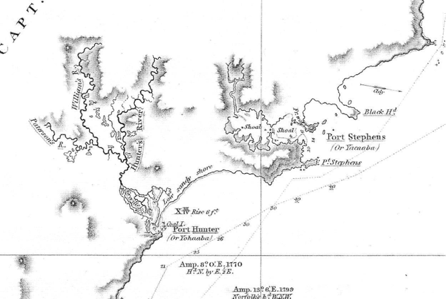
Matthew Flinders’ chart showing Black Head as part of the mainland. Note the track of Norfolk in which Flinders sailed close to Black Head in July 1799. Part of Chart of Terra Australia, Sheet 1, East Coast, National Library of Australia, NLA obj-232589531.
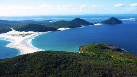
Cook’s ‘high round hills’ and the entrance to Port Stephens from Point Stephens island. Bank’s Journal records “At Sunset three remarkable hills were abreast the ship standing near the shore, of nearly equal size and shape…”
Port Stephens:
The second viewpoint is the summit of Tomaree Point, the south head of the Port’s opening to the sea. There is a scenic but steep path to the summit perched 161m above the beach. At the top there are magnificent views in every direction – north to the islands, south and east to Point Stephens, inland across the Port. From here you will see clearly that Black Head really is an island and not the headland it might appear to be from Point Stephens. The ‘high round hills that make at a distance like Islands’ which Cook saw ‘on the Main near the shore’ are evident. Tomaree is beneath your feet, Yacaaba Head looms as the north head of Port Stephens, while to the south is Stephens Peak and the hill above Point Stephens. All around are extravagant hills and verdant foliage – altogether an idyllic scene and one of the coastal highlights of Australia.
References:
Robert King, 'Putting Broughton Islands on the Map', Map Matters, Issue 14, June 2011, and Journal of Australian Naval History, vol. 9, No. 1, March 2012.